Showing posts with label History. Show all posts

Thursday, June 19, 2008

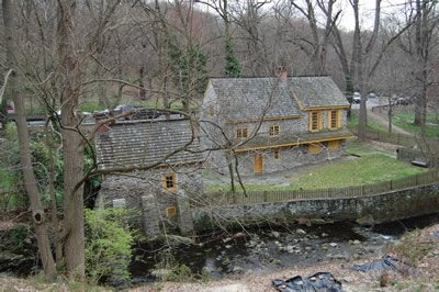
Livezey House (Glen Fern)

Livezey House.Livezey House, Sunday afternoon, June 15, 2008.
Directly across the creek, on the east bank, are the ruined walls of the "Great" or Livezey Mill, built in 1717 by Thomas Shoemaker, and for a long time the largest grist mill in the colony. It was sold to Thomas Livezey October 10, 1749. Sometimes hid in its little glen, but usually visible from the drive, is the Livezey House, built in 1696, now the picturesque home of the Valley Green Canoe Club. The kitchen in this house is believed to date to 1683.
-- The Wissahickon Valley Within the City of Philadelphia, Francis Burke Brandt, 1927

Ruins of Livezey Mill.Ruins of the Livezey Mill, Sunday afternoon.

Sunday, April 27, 2008

Rinker's Rock

Mom Rinker's Rock and Toleration Statue.
During [Edgar Allen] Poe's years in Philadelphia, 1839-1844, he often visited the Wissahickon. He advises those who would see the best of the creek to go out the Ridge Road to Roxborough, and, "taking the second lane beyond the sixth milestone, to follow this lane to its terminus." This route would bring him down to the creek almost opposite the Monastery. It was just below here, on Mom Rinker's rock, he saw the elk, that he wrote about in "Morning on the Wissahiccon," in The Opal for 1844.
-- The Wissahickon Hills, Cornelius Weygandt, 1930

Saturday, April 26, 2008

Blue Stone Bridge

Blue Stone BridgeBuilt in 1896, the Blue Stone Bridge, and before that, an earlier structure which it replaced, was the only way to cross the Wissahickon when traveling to and from Germantown and Roxborough. When conditions were bad -- think rain and mud, snow and ice -- it was not an easy journey. One had to travel up or down the steep trail through the gorge on the Roxborough side. In 1908 that changed with the opening of the Walnut Lane Bridge. Suddenly a day's journey became a journey of a minute or two.

Sunday, April 13, 2008

Bakehouse

Bakehouse, Historic RittenhouseTown.The old bakehouse at Historic RittenhouseTown. Built, I believe, in the early 1700s.

Saturday, April 12, 2008

Historic RittenhouseTown, spring evening

Historic RittenhouseTown. Historic RittenhouseTown, located along Lincoln Drive between Rittenhouse Street and Wissahickon Avenue, is the site of America’s first paper mill. It was the perfect place when William Rittenhouse and his family established their business in 1690 – the Monoshone Creek, also known as Paper Mill Run, supplied the power to run the mill, and the proximity to Germantown meant that there would be an ample supply of cast off linens, the raw material for making paper back then. Over the next century and a half, the Wissahickon Valley became a major center of industry, with mills of many types drawing their energy from the Wissahickon, Monoshone and Cresheim Creeks. Many of the older homes in my neighborhood, Blue Bell Hill, housed workers who made their living in the valley.

When I first moved to Blue Bell Hill -- fifteen years ago this April 29 -- I lived in a tiny house on Naomi Street, and RittenhouseTown was just a short walk down the hill through the woods. I soon became a volunteer tour guide for the site. Getting a sense of the area’s history helped me to feel more of a connection to my new community. Back then there were many families who had been in Blue Bell Hill for generations, including Rittenhouses. Clem Rittenhouse, in his eighties and a direct descendent of William, used to come down to the Visitor Center on Saturday afternoons and spend a few hours talking to the volunteers and the visitors. He had many memories and was a natural story teller, and having him there reminded us that history is, after all, always a story about people.

Tuesday, April 8, 2008

Dewee's Rock

Dewee's RockDewee's Rock, just off of Germantown Avenue where it crosses the Wissahickon.
In 1710 a group of local men, all with German or Dutch surnames, established the Whitemarsh Reformed Church in Chestnut Hill. It met in the two-story house of mill owner William Dewees, a structure (now demolished) that stood on Germantown Avenue opposite the present Chestnut Hill College grounds. The congregation broke apart, however, following Dewees's death in 1745.
-- David R. Contosta, Suburb in the City
A number of mills operated in this area. Below, probably the remains of an old mill race, built to better manage the flow of water that powered the mill's wheel.
Mill race.

Friday, March 28, 2008

Through thin ice

This plaque is on the eastern side of the Wissahickon, just north of Kitchen's Lane Bridge.
In 1722 Johannes Gumre and Peter Becker, leaders in the Germantown Baptist community, made a pilgrimage to Pennsylvania to find and reunite about 20 families who had arrived on this continent together in 1719 but had become separated. Their successful reunion as celebrated by a creek-side service where six new members, including three former Hermits of the Ridge, were baptized. The group had walker first through Germantown to a member's house to take their noon meal together and then along an Indian trail (probably where Carpenter's Lane is now) to the creek arriving very close to sunset. Elder Peter Becker led each candidate separately into the water through thin ice. The solemn rite ended after sundown.
-- Sarah West, Rediscovering the Wissahickon

Thursday, March 27, 2008

Serene reminder of a troubled time

This guardhouse, which stands near the intersection of Kitchen's Lane and Forbidden Drive, was built in 1938 by the WPA. In the late 1930s, during the height of the Depression, workers participating in the Works Progress Administration (WPA) built a number of similar buildings throughout the Wissahickon.

Thursday, March 20, 2008

Markers

St. Peter's Church, Sunday afternoon.
Although no official reported the number of Oneidas killed in the fight, some years afterward Pennsylvanians placed a plaque at St. Peter's Church Cemetery in Barren Hill that memorialized the SIX INDIAN SCOUTS WHO DIED IN BATTLE MAY 1778. According to the church's official history, at least four of them had been buried there, their graves marked by ordinary headstones, all in a straight line.
-- Joseph T. Glatthaar, James Kirby Martin, Forgotten Allies: The Oneida Indians and the American Revolution

Thursday, March 6, 2008

Borders and intersections

That's the Borders Book Shop at the top of Chestnut Hill, at the intersection of Germantown Avenue and Bethlehem Pike. Borders has been there since the early to mid 1990s. Before that, a succession of two Gulf stations occupied this spot since 1947. Before the Gulf stations, the Maple Lawn Inn operated from this location, and before that, the Yeakel General Store. This takes us back to the 1870s. It is more than likely that some commercial establishment stood here for most, if not all, of Chestnut Hill's three hundred year history.

One could make the case that the history of Chestnut Hill is founded on that coming together of these two roads -- Germantown Avenue and Bethlehem Pike -- originally two Native American trails.
For three centuries these two routes have served Chestnut Hill. Even in the late twentieth century, they provide the only direct road-ways through the center of the community. During the early decades, these roads allowed Chestnut Hill function as a what might be called a "gateway village." Like Charlestown and Cambridge outside Boston, and similar fringe communities near Baltimore and New York, Chestnut Hill sat astride a main road (in this case, two of them) that ran into the city and allowed the village to serve as a commercial gateway to the metropolis beyond.
-- David R. Contosta, Suburb in the City, 1992.
Although incorporated by Philadelphia in 1854, Chestnut Hill has maintained its village like character. This is in part because of its proximity to the Wissahickon Valley, which forms its western boundary and isolates it from the rest of the city.

Wednesday, March 5, 2008

Chestnut Hill: spiritual; municipal

Chestnut Hill Baptist Church, intersection of Bethlehem Pike and Germantown Avenue, Sunday, 1:45 in the afternoon. The belltower and clock, dating to 1847, are later additions to this structure built in 1835.

Chestnut Hill Firehouse, West Highland Avenue, Sunday afternoon, around 2:00. According to an article in the Chestnut Hill Local, this structure, built in 1894, is Philadelphia's oldest firehouse.

Sunday, March 2, 2008

Catfish and waffles

Valley Green Inn, Saturday afternoon, around 2:30.

In the middle of the 1800s, as the Wissahickon became a popular destination for tourists and day trippers out from the city, several road houses sprang up to cater to their desires for a meal or a drink. Only two of these buildings exist today: Wissahickon Hall, which now serves as the headquarters for the 14th police district, and Valley Green Inn, which is still a restaurant. A favorite dinner of the day was something called "catfish and waffles."

Catfish and waffles began with fried catfish and a relish. A steak of beef followed, with fried potatoes, generally a simple form of what we know now as hashed brown. Then came stewed chicken and the waffles. And after the chicken and the waffles, the coffee. Dessert was served at some places, too, but not invariably. As a veteran of many bouts with catfish and waffles said to me, You more often had ‘catfish and waffles’ with a wink than with a dessert. For my part I liked beer with ‘catfish and waffles.’ Catfish is a rich fish. It is fried in butter. That makes it richer. Good steak has streaks of fat through it, and there is butter in hashed-brown potatoes. Stewed chicken with gravy is rich too, even if the waffles sop up a good deal of the gravy. Coffee is not enough to settle such a dinner. You need a good hoppy beer. I know those liked a sour wine, a Rhine wine or the like. The trouble with such was that it took too much of it, and it came high. You wouldn't want whiskey after ‘catfish and waffles.’ Beer was the thing to settle it. It would do the trick.
-- The Wissahickon Hills, Cornelius Weygandt, 1930

Saturday, March 1, 2008

Thomas Mill Bridge

Historic Thomas Mill Bridge is the last remaining covered bridge within the city limits of Philadelphia. You will find it along Forbidden Drive, near mile post 1, about a half mile below the parking lots at Bell's Mill.

I'm having difficulty finding a precise history of the bridge, but it most likely dates to the middle of the 1800's. The structure was restored in 1938 by the WPA, and in 1999 by the City of Philadelphia.

These photos were taken late Friday Morning.

Monday, February 18, 2008

Washington and Lincoln

This plaque commemorates a local skirmish during the Battle of Germantown fought along the stretch of the Wissahickon that now borders, more or less, along Lincoln Drive. The rock to which it is fastened, for reasons unknown to me, is known as Washington's Rock. Since it is located just off of Lincoln Drive -- named for Abraham Lincoln -- it seemed an appropriate post for Presidents' Day.

The plaque, being over a hundred years old, and showing the effects of both nature and graffiti, is a bit hard to read. Here is what it says:

ON THE MORNING OF THE BATTLE OF GERMANTOWN, OCTOBER 4, 1777, THE PENNSYLVANIA MILITIA, UNDER GEN'L JOHN ARMSTRONG, OCCUPYING THE HIGH GROUND ON THE WEST SIDE OF THE CREEK OPPOSITE THIS POINT, ENGAGED IN A SKIRMISH THE LEFT WING OF THE BRITISH FORCES, IN COMMAND OF LIEUT-GEN'L KNYPHAUSEN WHO OCCUPIED THE HIGH GROUND ON THE EAST SIDE ALONG SCHOOLHOUSE LANE.
-- ERECTED BY THE PENNSYLVANIA SOCIETY OF SONS OF THE REVOLUTION, 1907

Sunday, February 17, 2008

General Lafayette Inn

The General Lafayette Inn, located at the intersection of Germantown Avenue and Church Lane, has been serving beer for 275 years. Well, at least part of this structure has been there that long -- originally called The Three Tuns -- and has been a tavern for most of that time. Surely the esteemed young general for whom the establishment is now named hoisted a few pints when he and his troops were holed up nearby in the fall of 1777. On this particular day -- Saturday, February 16 -- the inn was hosting a festival in which breweries from around the region were invited to share their winter beers with 250 ticket-holding patrons.

You can read more about the local beer culture at Beers of the Wissahickon. (Warning: shameless self-promotion.)

Saturday, February 16, 2008

Not evidence of life on Mars

That forty-five-degree angle gash in the rock face is what is left of a hole drilled to accommodate explosives when the roadway that is now Forbidden Drive was being blasted out, probably in the 1850s. You can find it, as well as a couple of others, in the massive outcropping of rocks on Forbidden Drive half way between Lincoln Drive and the Blue Stone Bridge.

Sunday, February 10, 2008

Toleration, another view

I'm cheating today -- this photo was taken two weeks ago, on January 26. I want to spend a little more time talking about this fellow.

The statue is known as Toleration, and stands as a tribute to the local Quaker tradition. It has been presiding over this spot on Rinker's Rock on the eastern ridge of the valley since 1883. To give you an idea of scale, he stands close to ten feet tall; this photo was taken from the trail at the bottom of Rinker's rock, maybe forty feet below. The Wissahickon itself runs about one hundred and fifty feet below.

The most outstanding characteristic of this statue, to me, is its obscurity. He's not easy to find, standing on a secluded outcropping of rock far from the most used trails. Most stumble upon him by accident.

Thursday, February 7, 2008

A thing of beauty

Wednesday, February 6, a little after noon.
The inn at Valley Green , three and three-quarter miles from the creek's mouth, and a mile from the Germantown Avenue, is a rendezvous of and delightful refreshment station for all. For many years a committee of public-spirited women have had it in their care. Here ends navigation for canoes, and here in winter there is excellent skating. Just above the inn Springfield Avenue comes down from St. Martin's over an arched bridge which is a thing of beauty.
-- The Wissahickon by T. D. Daly, 1922

Thursday, January 31, 2008

Face the face

Detail from an old water trough along Forbidden Drive between mile posts 4 and 4 and 1/2.
One of the delights of driving on the Wissahickon was the stops at watering troughs. Young bodies develop growing pains if too long subjected to the decorous sitting-still proper to a Germantown wagon. We always climbed down while father allowed Don or Nellie to have a drink at any of the watering places along the drive.
-- The Wissahickon Hills, Cornelius Weygandt, 1930.

Tuesday, January 29, 2008

Looking good for one hundred

Sunday afternoon, January 27.

The Walnut Lane Bridge turns one hundred this year. When it was constructed at the turn of the last century, it transformed the neighborhoods of Roxborough and Germantown, making it possible to travel from one to the other in minutes rather than in a day. It was a world class undertaking in engineering, being the largest poured concrete structure in the world, as well as boasting one of the largest central arches. Germantown's Cliveden of the National Trust will host an exhibit later this year commemorating the anniversary of the bridge's completion.

H'm, this would look good as a beer label.